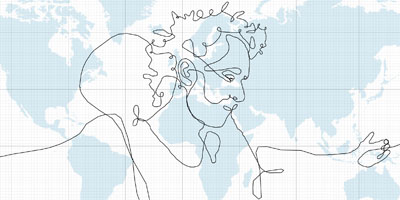
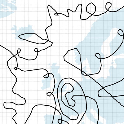
the biggest drawing in the world, created by GPS tracking & the help of express transportation company DHL. the pen was a briefcase containing a GPS device, being sent around the world. the paths the briefcase took around the globe became the strokes of the drawing. the giant strokes passed through 6 continents & 62 countries, becoming 110,664km long.
[link: ]
UPDATE: I was already a bit skeptical myself, having commercial ships/airplanes make 360 degrees turns above the ocean & all, but commenters have also made it clear this is a .
 Time and Date follows Time Zone (Brussels)
I find it a bit weird to be publishing this as a real news item when it's just a fictional concept, a very cool fictional concept none the less (if not a little unoriginal).
i just can say the same: tough this is a very nice concept, it`s quite disapointing to see that this is just a fake. It should have been at least mentioned in the article.
best
Cool! I saw several articles in the newspapers in Holland this morning, but none of them mentioned the bottom line "This is fictional work. DHL did not transport the GPS at any time" :D
the GPS tracking behind this art was disclosed as a hoax.
http://gpstracklog.typepad.com/gps_tracklog/2008/05/worlds-largest.html
thnkx for your comments all. the post has been updated accordingly. it was never my intention to mislead you.
You know what we (the readers of this blog) oughta do? Chip in/collect donations to do an actual "biggest drawing in the world," using similar technology/techniques. Something like this -- though possibly less elaborate -- should be possible given enough money and time, and now that this versions been proven a hoax, I personally really want to see it happen.
Hoax or not, a really interesting idea.