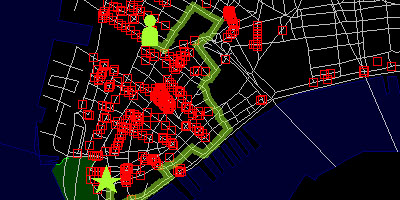
 a web-based application charting the precise locations of closed-circuit television (CCTV) surveillance cameras in urban environments. this map tool enables users to plot exact routes that avoid these cameras, thus creating 'paths of least surveillance'. [|via & ]
 Time and Date follows Time Zone (Brussels)
In the wake of the London suicide bombings, this story is pretty irresponsible.
See also the new Google Maps Web Cam Locator (US): Utilizing AWS's InstaCam network, Brady created a Google Maps Web Cam Locator that allows you to search for web cams by zip code. http://conversationswithmyself.com/maps/aws/gmapAWS.html
w0mbat, I appreciate your concern. this issue was also raised in the wired.com article (link in original post).