
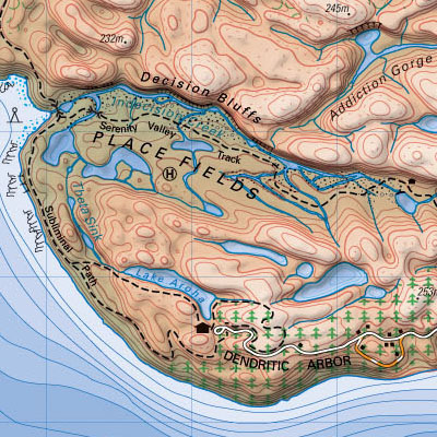
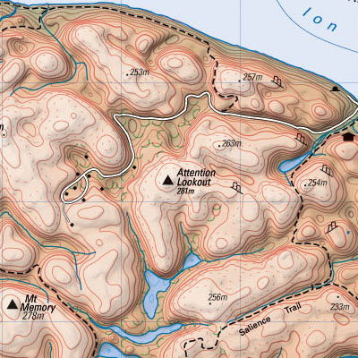
a geographical 3D terrain map of the human brain created from a reference photo. a real digital elevation model was then used to create contour line data, relief shading & to plan where the roads and features should be placed for map compilation. real-life New Zealand public domain data was then added for the surrounding islands.
[link: ]
 Time and Date follows Time Zone (Brussels)
Cute, but I was hoping it would incorporate more neurological details (metaphorically).
I feel this is one of the most appropriate times to say "Why didn't I think of that!"
88888888888888______88__88888888___88888888888888
88__________88__8888888888_88888___88__________88
88__888888__88______8888_______88__88__888888__88
88__888888__88____88__88___888888__88__888888__88
88__888888__88__88__88__88___88____88__888888__88
88__________88____8888888888888888_88__________88
88888888888888__88__88__88__88__88_88888888888888
__________________88__88__88_____________________
88__88__88__88____88__88888888_________88____88__
__888888__88____888888__88_____88__88________8888
88____8888__8888________8888_______88888888888888
______888888______88______88___888888________8888
__88____888888__888888888888___88__88__________88
888888____88______8888888888___888888__________88
__88__8888__88__88888888888888___88____8888888888
88__88____________88___8888888_888888________88__
__88__88____88888888__88__88_88888888888888__8888
________________88888888_____8888______8888____88
88888888888888____8888____88_8888__88__88____8888
88__________88________88__8888_88______88______88
88__888888__88__88__88__8888___8888888888____8888
88__888888__88____88888888___888_____8888________
88__888888__88__88__888888___888_____88888888__88
88__________88______88__88888888888__________88__
88888888888888__8888888888__888888_____88____8888
Great idea. However my brain map would be considerably smaller!